
Camp U-No Guidebook
Food scene
Copper Pig Brewery
1 Middle StGreat local brewery with amazing food!
Polish Princess Bakery
73 Main StWonderful spot for a treat or lunch!
The Granite Grind
70 Main StOne of our favorite spots! Don't pass up the pretzels and pizza!
146 il-persuni tal-post jissuġġerixxu
Schilling Beer Co.
18 Mill StOne of our favorite spots! Don't pass up the pretzels and pizza!
Sightseeing
Mount Washington Cog Railway
3168 Base Station RdThe Presidential Rail Trail (PRT) was established in 1997. Its 18-mile length runs from Gorham in the east to Cherry Pond in the west, and is currently administered by the New Hampshire Division of Parks and Recreation. The current permitted uses on the PRT are: hiking, biking, cross-country skiing, snowshoeing, snowmobiling and mushing.
Throughout much of its length the PRT spans the base of the northern Presidential Mountains, including Mt. Madison, Mt. Adams, and Mt. Jefferson. It passes through the towns of Gorham, Randolph, Jefferson, and Whitefield. In Randolph it includes the headwaters of two pristine river systems, with the Moose River flowing eastward into the Androscoggin’s drainage and Israel’s River flowing westward to the Connecticut. The Moorhen Marsh and Cherry Pond at the western end of the trail offer spectacular panoramas of the Presidential Range. At Cherry Pond there is an accessible trail that ends at a viewing platform.
The rivers and associated wetlands support fishing in season, birding and wildlife observation. Three major trailheads abut and cross the PRT at Bowman, Appalachia, and Randolph East. These attract thousands of hikers to the northern Presidential area each year. In snowless times of the year the Rail Trail itself provides opportunities for quiet recreation throughout its length; in particular it offers bicyclists a respite from the heavytraffic and narrow road on nearby US Rte 2.
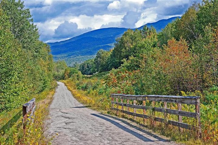
Presidential Range Rail Trail
Dolly Copp RoadThe Presidential Rail Trail (PRT) was established in 1997. Its 18-mile length runs from Gorham in the east to Cherry Pond in the west, and is currently administered by the New Hampshire Division of Parks and Recreation. The current permitted uses on the PRT are: hiking, biking, cross-country skiing, snowshoeing, snowmobiling and mushing.
Throughout much of its length the PRT spans the base of the northern Presidential Mountains, including Mt. Madison, Mt. Adams, and Mt. Jefferson. It passes through the towns of Gorham, Randolph, Jefferson, and Whitefield. In Randolph it includes the headwaters of two pristine river systems, with the Moose River flowing eastward into the Androscoggin’s drainage and Israel’s River flowing westward to the Connecticut. The Moorhen Marsh and Cherry Pond at the western end of the trail offer spectacular panoramas of the Presidential Range. At Cherry Pond there is an accessible trail that ends at a viewing platform.
The rivers and associated wetlands support fishing in season, birding and wildlife observation. Three major trailheads abut and cross the PRT at Bowman, Appalachia, and Randolph East. These attract thousands of hikers to the northern Presidential area each year. In snowless times of the year the Rail Trail itself provides opportunities for quiet recreation throughout its length; in particular it offers bicyclists a respite from the heavytraffic and narrow road on nearby US Rte 2.
Mount Washington, called Agiocochook by some Native American tribes, is the highest peak in the Northeastern United States at 6,288.2 ft (1,916.6 m) and the most topographically prominent mountain east of the Mississippi River.
The mountain is notorious for its erratic weather. On the afternoon of April 12, 1934, the Mount Washington Observatory recorded a windspeed of 231 miles per hour (372 km/h) at the summit, the world record from 1934 until 1996. Mount Washington still holds the record for highest measured wind speed not associated with a tornado or tropical cyclone.[4][a]
The mountain is located in the Presidential Range of the White Mountains, in Coös County, New Hampshire. The mountain slopes lie within the boundaries of several unincorporated townships, with the summit itself lying in the township of Sargent's Purchase. While nearly the whole mountain is in the White Mountain National Forest, an area of 60.3 acres (24.4 ha) surrounding and including the summit is occupied by Mount Washington State Park.
The Mount Washington Cog Railway ascends the western slope of the mountain, and the Mount Washington Auto Road climbs to the summit from the east. The mountain is visited by hikers, and the Appalachian Trail crosses the summit. Other common activities include glider flying, backcountry skiing, and annual cycle and running races such as the Auto Road Bicycle Hillclimb and Road Race.
132 il-persuni tal-post jissuġġerixxu
Mount Washington
Mount Washington, called Agiocochook by some Native American tribes, is the highest peak in the Northeastern United States at 6,288.2 ft (1,916.6 m) and the most topographically prominent mountain east of the Mississippi River.
The mountain is notorious for its erratic weather. On the afternoon of April 12, 1934, the Mount Washington Observatory recorded a windspeed of 231 miles per hour (372 km/h) at the summit, the world record from 1934 until 1996. Mount Washington still holds the record for highest measured wind speed not associated with a tornado or tropical cyclone.[4][a]
The mountain is located in the Presidential Range of the White Mountains, in Coös County, New Hampshire. The mountain slopes lie within the boundaries of several unincorporated townships, with the summit itself lying in the township of Sargent's Purchase. While nearly the whole mountain is in the White Mountain National Forest, an area of 60.3 acres (24.4 ha) surrounding and including the summit is occupied by Mount Washington State Park.
The Mount Washington Cog Railway ascends the western slope of the mountain, and the Mount Washington Auto Road climbs to the summit from the east. The mountain is visited by hikers, and the Appalachian Trail crosses the summit. Other common activities include glider flying, backcountry skiing, and annual cycle and running races such as the Auto Road Bicycle Hillclimb and Road Race.
Ammonoosuc Lower Falls Trailhead
Lower Falls RoadGreat place to swim and fish.
Pondicherry Wildlife Refuge
289 Airport RoadFamily Fun
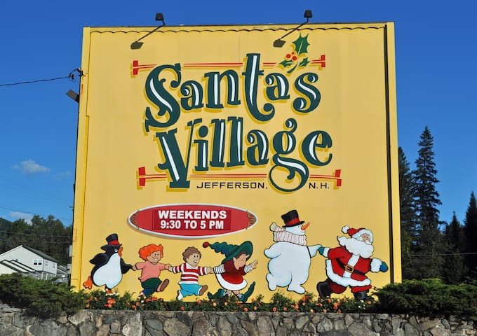
Santa's Village
528 Presidential Hwy